


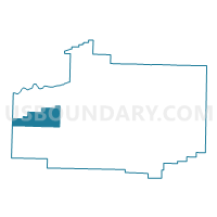
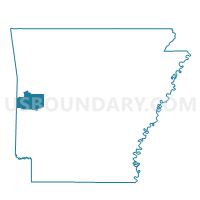
Brawley Voting District, Scott County, Arkansas
About
Outline

Summary
| Unique Area Identifier | 528096 |
| Name | Brawley Voting District |
| County | Scott County |
| State | Arkansas |
| Area (square miles) | 30.99 |
| Land Area (square miles) | 30.00 |
| Water Area (square miles) | 0.99 |
| % of Land Area | 96.81 |
| % of Water Area | 3.19 |
| Latitude of the Internal Point | 34.86177860 |
| Longtitude of the Internal Point | -94.31877960 |
Maps

Graphs
Select a template below for downloading or customizing gragh for Brawley Voting District, Scott County, Arkansas


Neighbors
Neighoring Voting District (by Name) Neighboring Voting District on the Map
- Voting District 307, Le Flore County, OK
- Black Fork Voting District, Scott County, AR
- Blansett Voting District, Scott County, AR
- Cauthron Voting District, Scott County, AR
- Lafayette Voting District, Scott County, AR
- Oliver Voting District, Scott County, AR
Top 10 Neighboring County Subdivision (by Population) Neighboring County Subdivision on the Map
- Heavener CCD, Le Flore County, OK (9,315)
- Cauthron township, Scott County, AR (160)
- Blansett township, Scott County, AR (158)
- Brawley township, Scott County, AR (106)
- Lafayette township, Scott County, AR (78)
- Black Fork township, Scott County, AR (66)
- Oliver township, Scott County, AR (59)
Top 10 Neighboring Elementary School District (by Population) Neighboring Elementary School District on the Map
Top 10 Neighboring Unified School District (by Population) Neighboring Unified School District on the Map
- Waldron School District, AR (9,473)
- Heavener Public Schools, OK (5,107)
- Ouachita River School District, AR (4,356)